Fourth Stop: South Lake Tahoe
Travel Log: 10 October 2011
This day was not about the stop, but completely about the journey.
Fourth Stop: South Lake Tahoe, California
This was going to be a SOLID 12 hour day of driving. Like the trek from IC to EP, we would be driving straight from Moab, Utah to South Lake Tahoe, California. That means driving 90% across Utah and 100% of Nevada, stopping just a few feet from the Nevada border in California.
The drive across the middle of Utah and Nevada is the less traveled path with gas stations marked by the number of miles to the next, 100 miles the norm. However, the view of the drive, oh my, oh my. The morning sunrise drive across Utah was breathtaking, the rolling hills, the intermixing of the red sandstones and the navajo sandstones, the buttes and mesas jutting up here and there, and the green brush spattered throughout.
The four lane interstate through Utah abruptly takes a sharp turn to the south, refusing to go into Nevada. Turns out the two states had a big disagreement ages ago and Utah refused to make their interstate end in Nevada. Because of this, you have to continue west on the two lane Highway 50, the path of the original Lincoln Highway across America.
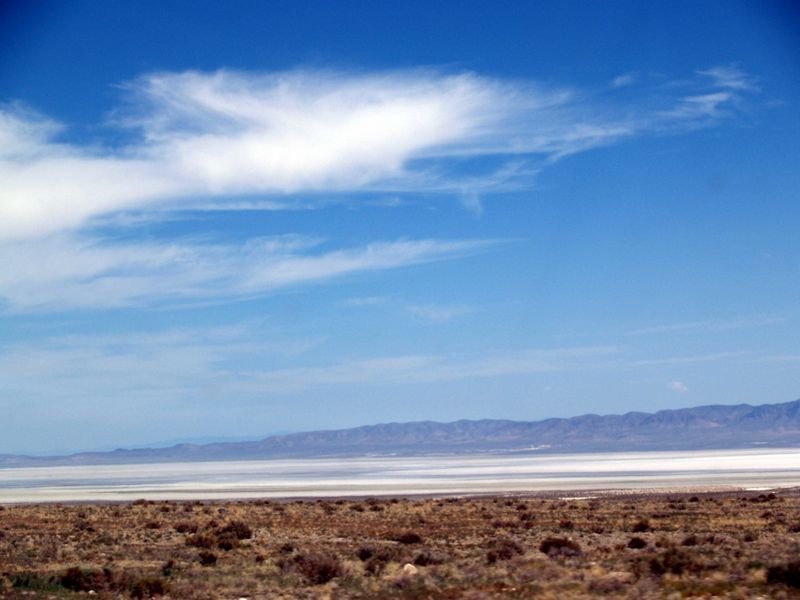
While the Utah section of this road is not well maintained, you do get to drive past the Sevier Lake, a dry salty lake in western Utah. The white auora of the salt mixed with the haze of the sun and desert, created this moonlike glow in the horizon and we couldn't help but stop. The signs warn of a $500 fine for having to be towed out of the lake and you can see the tire tracks of donuts that were spun. Josh and the kids walked along the edges and had the odd experience of walking on something that isn't dry but it isn't wet, either.

(Photo credit because I can't access my photo database right now, eekk! But this accurately shows what Sevier Lake is like.)
Once in Nevada, the quality of the road of Highway 50 increases as the speed limit increases to 85mph. Prior to leaving IC, Josh had read up on this road and learned via Wikipedia that this 409 mile highway through Nevada was nicknamed "The Loneliest Road in America" by Life magazine in 1986. This is a completely accurate description. We also read up on the three towns and one tiny ghost town, each spaced about 100 miles apart. Stephen King had driven this Highway 50 and used the tiny ghost town of Ruth as inspiration for his book, Desperation. (Which my husband found appropriate to read when he wasn't driving, :)!)
The geography of Highway 50 through Nevada is something else. For 25 miles you drive on a flat, generally straight road, sometimes desert or plains, with nothing in sight, no cars, no houses, no wires, no signs, nothing. But off in the distance you can see a mountain range. And as you reel in the range, it isn't until you are right at its base that you are quickly shot zig-zagging up 2000-3000ft and then quickly brought back zig-zagging down again and you are driving on the flat incredibly straight road, sometimes desert or plains,... but off in the distance you can see the next of the total 17 mountain passes you will be quickly be thrust up and over.
The funny thing about Highway 50, though, was how different we felt while driving it. As we were well into the rhythm of flat plains to sharp mountain pass to flat plains again, I was slowly becoming more and more depressed and I could not wait to get off this ridiculous road. At the same time, my husband was becoming very introspective and thinking deep. meaningful thoughts about his life and loving every minute of it.
US 50 from Josh Cramer on Vimeo.
(This video is of our return trip on US50, but I wanted you to experience it now.)
The part of the final leg of this journey does include what the state of Nevada has called "The Most Dangerous Highway in the State," the 50 mile portion of highway between Fallon and Dayton. However, after that and Carson City, it is a beautiful mountainous drive up to South Lake Tahoe, California.
Fourth day of driving: 12 hours, 728 miles
Our hotel was directly across the state line to Nevada, the neon casino lights were brighter than the ones in our hotel room. We threw together a hodge podge dinner with the scarce restaurants still open and went to bed, completely wiped, but once again thankful for another safe drive.
What we didn't know was that our dairy allergy child had got ahold of some dairy and tomorrow would prove to be a massive challenge of patience.


Response to Fourth Stop: South Lake Tahoe